Butterfield Overland Mail Route in Oklahoma

The Butterfield Trail (1858-1861) in Indian Territory used the federal Ft. Smith-to-Boggy Depot Indian immigration and supply road. It followed the Texas Road on to Colbert's Ferry on Red River. Twelve Butterfield Stations, spaced about 16 miles apart, were located in Indian Territory. The Confederate Army relied on this road to move troops and supplies from North Texas to Ft. Smith during the War Between the States until Ft. Smith was captured September 1, 1863. Confederate reinforcements, under CS BG Bankhead were marching up the road when Ft. Smith fell to US MG Blunt's forces. CS BG Cooper (with BG Gano and BG Watie) used the road to attack Ft. Smith in late July 1864.
 
A Special Thank-you to Dr. Carroll Messer of College Station, TX. Dr. Messer located the majority of the sites related to the Butterfield Trail in Oklahoma.

 
www.CivilWarAlbum.com Home
Civil War in Indian Territory Home
Civil War in Indian Territory Index
 
Misc:

1. 1858 Woodcut: Butterfield Stage first trek across the SW
2. 1858 Woodcut: First eastbound stage from San Francisco
3. 1958 4¢ Postage Stamp
4.
2004 Painting: Butterfield Stage at Boggy Depot
5. Butterfield Overland Mail Centennial (1858-1958)
 
Maps:
1. Colbert's Ferry-Geary's Station
2. Geary's Station-Waddell's Station
3. Waddell's Station-Holloway's Station
4. Riddle's Station-LeFlore County

5. San Antonio & San Diego & Butterfield Overland Mail Lines
6. Butterfield Stage Route-Oklahoma: Google Maps
7. Smithsonian National Postal Museum
8. Road from Ft. Smith to Red River via Boggy Depot
9. Map of Fisher's Station from 1871 Survey
  Links:
1. Butterfield Overland Mail in Indian Territory - Wikipedia
2. Exploring Oklahoma History-Butterfield Overland Mail Rt
3. Butterfield Overland Mail
4. Fort Tours | Butterfield Overland Mail Route Stations
5. Atoka County Oklahoma Genealogy

6. Opening Of The West - Butterfield Overland Mail Co.
7. Butterfield Overland Mail One Hundred Years Ago (pdf)
8. Butterfield Overland Mail in Indian Territory | Facebook
9. Committee Report Butterfield Overland Mail (pdf)
10. Trails West: Across the Southwest & Cattle Trails
11. National Postal Museum: Butterfield Overland Mail
12. Butterfield Overland Mail: FamilySearch.org
13. Fayetteville Manuscripts: Butterfield Overland Mail
14. Butterfield Overland Mail: stitching the country together
15. Historic places on the old stage line from Fort Smith to Red River
Photos:
1st Choctaw & Chickasaw Mounted Rifles
Atoka: 150th Commemorative Marker   2
Blackburn's Station
Blue River
Boggy Depot
Brazil Station
Brazil Valley
Buck Creek Mountain
Butterfield Road
Carriage Point
Choctaw Agency House-Walker's Station
Choctaw Council House
Choctaw National Cemetery
Colbert's Ferry
Colbert's Ferry Stage Stand
Colbert Toll Bridge
Edwards Store 2  3  4
Fisher's Station
Fisher's Station Road
Geary's Station
General  Frank C. Armstrong
Holloway's Station
Mountain Station   2
Nail Family Cemetery
Nail's Crossing
Nolitubbee Creek Crossing
Old Fort Smith/Boggy Depot Road
Private Thomas Lewis Rider
Pvt Thomas Rider Grave at Fisher's Sta.
Pusley's Station
Red River
Riddle Cemetery
Riddle Home
Riddle's Station
Road Trace   2   3   4   5   6   7   8   9   10
Skullyville   2
Tandy Walker
The Narrows
Trahern's Station
Waddell's Station
Walker's Station  2
Wesley Road
Panoramas:    
Boggy Depot (2)
Brazil Creek Bottom Land
Brazil Station
Fisher's Station (3)
Holloway's Station
Pusley's Station
Riddle Cemetery
Trace of the Butterfield Trail
Trahern's Station
Walker's Station   2
     
Butterfield Route Page1   2   3   4   5   6   7   8   9   10   11   12   Next
 

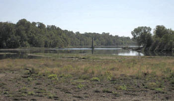
(October 2011) Enlarge Map Colbert's Ferry site and remains of the Colbert toll bridge on Red River, near Colbert, Bryan County. View looking downstream from Oklahoma side of river

Colbert's Ferry Historical Markers:
1. Texas Information Center, US-69/75, north of Denison, TX

2. Downtown Colbert, OK

N33 49'07.05 W96 31'21.91

Links:
1. Colbert's Ferry | The Handbook of Texas Online
2. Colbert's Ferry: Oklahoma Historical Society

3. PassportsRedRiver: BourlandCivilWar.com
4. Colbert's Ferry - Wikipedia

5. 150th Anniversary - Butterfield Overland Mail in Texas
 
Photo by Dr. Carroll Messer, College Station, TX

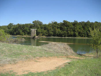
(August 24, 2012) Enlarge Colbert toll bridge site from Texas side of Red River. Colbert's Ferry crossed the river approximately 1/3 mi. downstream (right) from the bridge

Photo by Dr. Carroll Messer, College Station, TX


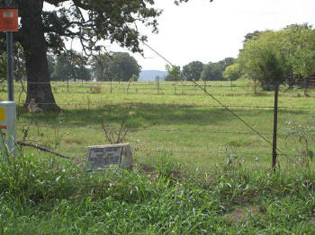
(August 24, 2012) Enlarge  Detail Oklahoma Historical Society marker for Colbert's Ferry Stage Stand. River Road about 1 1/2 mi. southeast of Colbert, Bryan County. Trail went south past B. F. Colbert home to the Ferry Crossing of Red River into Texas, seen in the far (center) background

The large tree on the left is the "Hanging Tree" whose picture is shown and hanging described in reference Link 5 above

N33 49'06.13 W96 30'58.10
 
Photo by Dr. Carroll Messer, College Station, TX

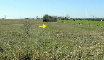
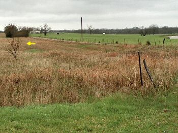
(March 12, 2012) Enlarge Map Trace of the Butterfield stage route. 1 1/2 mi. west and 1 mi. north of Calera on Kirsey Road, Bryan County
 
At this location the trace runs north and south parallel to Kirsey Road. Yellow arrow marks the trace. It runs from the fence in the foreground (north) to the clump of trees (south) at the edge of Kirsey Road
 
This section of the stage route is approximately 2 1/4 mi. south of Fisher's Station (Carriage Point)


N33 57'16.12 W96 27'40.00
 
Photo by Webmaster


(March 8, 2012) Enlarge Another view of the trace west of Calera
 
Photo by Webmaster


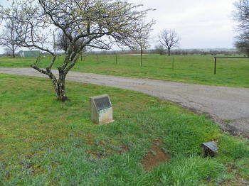
(March 8, 2012) Enlarge Map Oklahoma Historical Society marker for Fisher's Station (Carriage Point) 1 mi. south of US-70 on Fisher's Station Road, west of Durant, Bryan County. View looking southeast
 
N33 59'7 W96 27'16

Map of Fisher's Station from 1871 Survey

Links:

1. Fisher's Station - Wikipedia
2. Fort Tours | Butterfield Overland Mail Route Stations
3. Bryan Co., OK; Historic Sites in Bryan County - History ...
4. Fisher's Station - eNotes.com Reference

5. Bryan County: Encyclopedia of Oklahoma History & Culture
6. Chronicles of Oklahoma: Temporary markers of historic points
7. National Register Properties in Oklahoma: Carriage Point-Fisher's Station

 
Photo by Webmaster


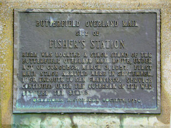
(March 8, 2012) Enlarge Fisher's Station marker
 
Photo by Webmaster
 

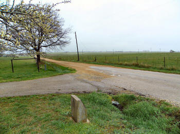
(March 8, 2012) Enlarge At Fisher's Station the stage route continues south-southwest to Colbert's Ferry on Red River. View looking south
 
Photo by Webmaster

Civil War in Indian Territory Home     Site Index     Butterfield Route Page1   2   3   4   5   6   7   8   9   10   11   12   Next