Battle of Raymond Page4

Raymond Page1     Page2     Page3     Page4     Page5     Page6     Page7     Page8     Page9     Next

(March 2007) Enlarge The battlefield from McPherson Ridge. Water tower in the distant left background marks Bledsoe's Confederate battery


(March 2007) Enlarge McPherson Ridge
 
Links:
1.
Battlefield Detectives - Friends of Raymond
2.
Raymond Battlefield Walking Trail Project


(January 2001) McPherson Ridge from Jct. of SH-18 and Cidero Road
  
Photo courtesy of Brian Risher


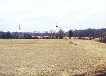
(January 2001) The view is looking north from the approximate center of the Raymond Battlefield. Fourteen Mile Creek runs across the photo in the distant background. Green arrow points to the SH-18 (Utica Road) Fourteenmile Creek Bridge. Red arrow points to a silver water tower standing near the site of Confederate Capt. Hiram Bledsoe's three-cannon Missouri battery. The battery covered the bridge across Fourteenmile Creek
  
Photo by Brian Risher
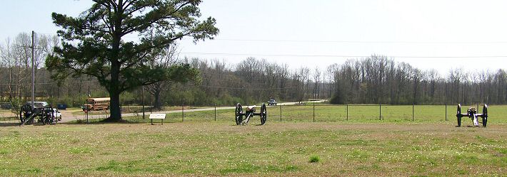
 

(March 2007) Enlarge Site of CSA Capt. Hiram Bledsoe's three-canon battery from Old Port Gibson Road
 
Links:
1. History of Bledsoe's Battery
2. Hiram Miller Bledsoe, Jr (1825 - 1899) - Find A Grave Memorial


(February 2020) Enlarge Capt. Hiram Bledsoe's three-canon battery from Old Port Gibson Road

  (February 2020) Enlarge Interpretive Marker in previous photo
 
(March 2009) Enlarge Bledsoe's battery
 

(March 2007) Enlarge Bledsoe's Battery marker

Raymond Page1     Page2     Page3     Page4     Page5     Page6     Page7     Page8     Page9     Next

Return to Yazoo Pass-Siege of Vicksburg     Return to Vicksburg Campaign Photo Album