| Champion Hill Home |
| Civil War Album Home |
| Return to Yazoo Pass - Siege of Vicksburg |
|
|
||||||
|
|
||||||
|
Area Map | |||||
 |
 |
|
|
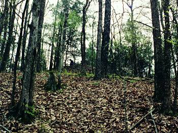
The
northwestern slopes of Champion Hill. Union soldiers under Hovey ascended
this portion of the hill quite rapidly, considering the steep terrain.
Notice Bruce standing at the top of the slope near where the Confederate
battle line would have been. Just past him about 50 yards would be the
crest of Champion Hill. The view is looking south
Locate on Map
|
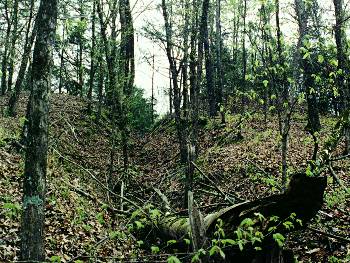
This picture shows the deep ravines that dot the landscape of the approaches to Champion Hill. While these ravines were difficult to navigate for the attacking Federals, they provided a safe haven from Confederate rifle and artillery fire from above. The photograph was taken looking south from near the same area as the previous picture |
|
 |
 |
|
|
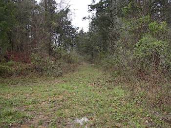
Just to the
south of the slopes from the previous picture is a sizable gravel pit, which
is visible above. The crest of Champion Hill is in the clump of trees on
the left side of the picture. At the time of the battle, however, Champion
Hill was one continuous rise from the slopes in the last two photos to the
crest. The Jackson Road took a sharp left hand turn here on its way to the
crossroads. It can be seen on the left side of the photo as well. The
trace seen going into the picture does not correspond to any wartime roadbed
and is most likely a postwar trail. The view is looking southward
Locate on Map
|
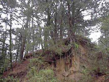
The crest of
Champion Hill looking southward taken from the gravel pit. During the
battle, Confederates had posted four pieces of artillery on this high
ground. Despite its natural commanding position, the Confederates were not
massed strong enough on the hill to successfully repel an attack by a
determined enemy. Their position and their artillery were captured quickly
from the onslaught by the Federals under Hovey
Locate on Map
|
| Assault Page1 Page2 Page3 Page4 Page5 Page6 Next |
 |