|
(12-2007)
Enlarge
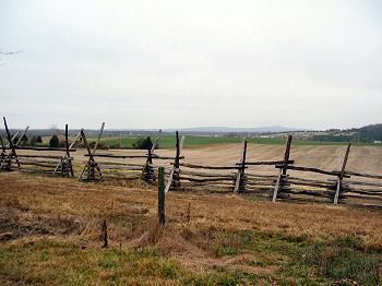
Confederate Artillery Line. One of the objectives of the Federal infantry
attacks was Confederate artillery posted diagonally in the field to the
right, between the road and the stand of trees in the distance. This road,
General Winder Road (CR 657), runs the path of what was Crittenden Farm
Lane at the time of the battle. Where the modern road turns (and takes up
the historical route of the Orange and Culpeper Road), was a gated
entrance to the Crittenden farm |
|
(12-2007)
Enlarge
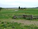
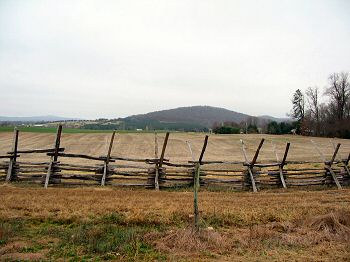
Crittenden Gate. The trail head for the Cedar Mountain walking trail. The
original path of the Orange and Culpeper Road is to the right of the
snake-rail fence. Crawford's Federals broke through Confederate lines at
this point, where disparate hand-to-hand fighting occurred. Jackson
rallied the Confederates and prevented a full route, while General A.P.
Hill's division arrived to reinforce the line |
|
(12-2007)
Enlarge
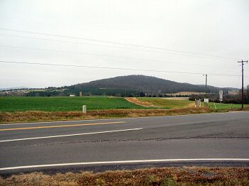
Looking across the Cornfield at the Federal lines. Some of the Federal
artillery positions are visible from the old Orange and Culpeper Road bed.
Near the modern day grain silo in the distant center, runs Mitchell's
Station Road (modern day CR 649) where Knap's, Roener's, Robinson's, and
McGilvery's batteries were posted. The high ground near the silo is
approximately McGilvery's position. The Federal artillery was at a
disadvantage in elevation and was somewhat flanked by the Confederate
artillery on the shelf of Cedar Mountain (seen on the right). The range
between the artillery positions was around 1000 yards |
|
(12-2007)
Enlarge
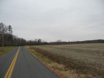
Looking East across the Confederate Position. This view is directly
opposite photo 3. Placed diagonally from this point back to the Crittenden
Farm Lane (Present Day General Winder Road, CR 657), which ran from the
tree line on the right of this photo towards Cedar Mountain in the distant
center. The small knoll mentioned on the marker, also called "The Cedars"
in some accounts, where other Confederate artillery was posted, is in the
bright green winter wheat field seen in the distance before Cedar
Mountain. The "Shelf of Cedar Mountain," where additional Confederate
artillery under General Ewell was positioned, is in the dark green stand
of trees on the lower slopes of Cedar Mountain |