|
Monocacy Page5 Photos/text this page courtesy of Craig Swain, Leesburg, VA For any use of these photos contact Webmaster |
||
 |
 |
|
|
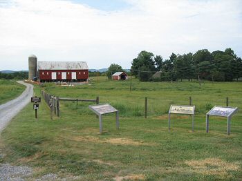
(September 2007) Enlarge The Thomas Farm tour stop. This 240 acre farm was also known as "Araby" and was operated by Christian Keefer Thomas at the time of the battle. The farm dates to 1780s, with a two story manor house (to the right, out of picture) and several farm buildings dating to the Civil War period. The park service acquired the farm in 2001 but the house and other buildings are undergoing preservation |
(May 2007) McCausland's second attack of the day, referenced at the Worthington Farm stop, occurring at 2:30 p.m. landed here and initially drove the Federals back to the Georgetown Pike (modern day Araby Church Road) to the north (direction of view). The Federals were elements of Truex's Brigade, of Rickett's Division (1st Brigade, Third Division, VIth Corps). Regiments involved with this phase of the operation were the 87th Pennsylvania, the 14th New Jersey, and the 106th and 151st New York. The Federals counterattacked and drove the dismounted cavalry back again, and setup a defensive line along the farm road |
|
 |
 |
|
|
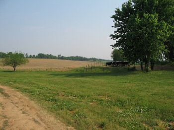
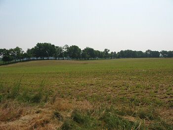
(May 2007) Evan's Attack. This view is looking northwest from the barn across the front of what was the Federal lines. Following the withdrawal of McCausland's cavalry, Gordon' committed Evan's Georgia Brigade, who advanced over Brooks Hill (crossing over what is today I-270) and attacked the Federal salient formed here at the Thomas Farm. Evan's attack landed at around 3:30 p.m. and initially stalled, with Evans being wounded. General Gordon appraised the situation and feared his division lacked the force to drive back the Federals. When General Breckinridge informed Gordon that Echol's Brigade (Commanded incidentally by Colonel George S. Patton, great-grandfather of the World War II general), was not yet up, Gordon committed York's Louisiana Brigade to support Evans. York's Brigade would hit the Federals along a farm lane approximately at the treeline in the distant center of the photo |
(May 2007) Enlarge York's Attack. This view is from the treeline along the farm line looking back to the Thomas Farm. The tree line is not historic, and the ground here was open pasture at the time of the battle. York's Louisianans hit the Federal center at a bow in their lines. This point was an apex where Federal lines extended to the east (generally the line of sight to the barn in the photo) and the north (to the left out of frame). York's attack landed at around 3:45 p.m. and met with qualified success. The Federals to York's and Evan's front fell back to the Georgetown Pike (modern Araby Church Road) |
|
 |
 |
|
|
(May 2007) Terry's Brigade and Gordon's final attack landed at around 4:00 p.m. The veterans of the Stonewall Brigade advanced using the trees and low ground around the river as cover, then crossed this open pasture and drove the Federal right flank back from the river. That would expose the Georgetown Pike and the now burning covered bridge. Note the timing of Gordon's attacks here. Each fell about fifteen to twenty minutes apart. Gordon's initial plans appear to have been only feeling out the Federal left flank in reaction to McCausland's repulse. After asking for reinforcements, he then committed his remaining forces in turn across the front, and not on the Federal's exposed flank. While such a flank attack might have seriously threatened the Federal lines of retreat, had Gordon moved troops into such positions the final attacks would have been pushed back by a half hour or more. Thus Gordon's decisions were probably the best possible at the time |
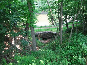
(May 2007) Enlarge
This stone
culvert was built for access of the Thomas Farm lane to the Georgetown
Pike. While this section of the battlefield did not factor significantly
in the fighting, the National Park Service recently opened an interpretive
trail loop through this section with emphasis on the 19th century farm
sites and prehistoric hunting camps found here. Just down from this
culvert is the Middle Ford where a ferry operated until the 1830s, when
rendered redundant by the covered bridge. Traces of the old Georgetown
Pike connecting to the ferry site instead of the covered bridge pass
through the fields nearby, with at least one tree historians date to the
time of the battle |