|
 |
|
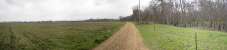
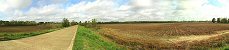
1. From
Old US-80 east of
Confederate defense, March 17, 2001 |
|
|
 |
|
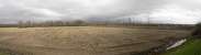
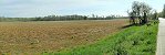
2. From Union perspective near US-80,
1/2 mile east of CSA defense, July 16, 2001 |
|
|
 |
|
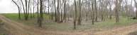
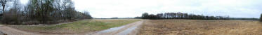
3. From 0.6 mi. east of left flank of
CSA defense, March 17, 2002 |
|
|
 |
|
4. 360 of CSA defense between railroad
and Gin Lake,
March 17, 2002 |
|
|
 |
|
5. CSA defense north of Old US-80,
March 20, 2002 |
|
|
 |
|
6. Meander scar parallel to Big Black
River, east of left flank of CSA defense |
|
|
 |
|
7. Same scar above, but 1/4 mi. farther
west |
|
|
 |
|
8. View from camera position above
looking toward CSA defense |
|
|
 |
|
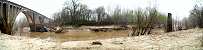
9. Big Black River wartime R/R bridge
site |
|
|
 |
|
10. Area east of Confederate defense,
north of railroad, March 2012 |
|
|
 |
|
11. Area west of Confederate defense,
north of old US-80, March 2012 |
|
|
 |
|
12. Right flank of Confederate defense
south of railroad, March 2009 |