|
Battle Description:
On April 19, 1862, Confederate troops repelled Union troops for five hours
at
Sawyer's Lane, retreating to fortifications 2 miles north at Joy's
Creek only after being outflanked from the east. Both sides claimed
victory: the North because they
captured the field and the South because
they prevented the destruction of the
Dismal Swamp Canal Locks, 3 miles
northwest in
South Mills, North Carolina.
The Confederate troops retreated north to the locks at Wallaceton in
Virginia during the night to prevent being outflanked from the east again.
Union forces retreated back to their transports at
Chantilly on the
Pasquotank River around 10:00 p.m., fearing the Confederates were
receiving reinforcements from Norfolk. A Confederate force of about four
thousand men was sent from Suffolk through Gates County in an attempt to
cut the Yankees off from their ships, but they arrived too late.
General Jesse Reno's Union forces consisted of three regiments from
Roanoke Island and two from New Bern. They were accompanied by a
detachment from the
1st New York Marine Artillery and underwater
explosives expert,
Professor Benjamin Maillefert, of New York City. Their
objective was to blow up the locks at South Mills, cutting off the major
route for supplies to Norfolk and denying Confederate ironclads a route to
the
Albemarle Sound. The fear of ironclads was unfounded; the canal was
far too shallow and narrow for the CSS Virginia's passage.
The Union battle plan called for
Colonel Rush Hawkins and his Fourth
Brigade from Roanoke Island to land at Chantilly under the cover of
darkness, followed by a twelve mile forced march to South Mills. They were
to capture and hold the bridge over the Pasquotank River below South
Mills, preventing the seven Third Georgia companies posted on the
Pasquotank County side of the river from crossing over into Camden County.
Reno was to follow with his two regiments from New Bern and the explosives
to blow up the locks.
In the darkness, Hawkins and his Fourth Brigade took a
wrong turn onto
Gumberry Road, arriving at
Belcross around dawn. They stopped at the
house
of Lieutenant Alonzo Bell on
Lamb's Road to eat breakfast. Hawkins
recognized Bell as one of the paroled captives from the Battle of Hatteras
Inlet. After eating, the Union column continued down Lamb's Road toward
South Mills, an unintended detour of about 5 miles. Hawkins blamed the
blunder on treachery by his local guide.
In the meantime, Reno's column left Chantilly at dawn and followed the
most direct route past
Camden Court House, stopping to rest at
Lamb's
Corner around 10:00 a.m. While stopped, clouds of dust and flying colors
were espied approaching from the east down Lamb's Road. Reno called his
men into
line of battle and prepared to fire on the approaching force,
thinking Hawkins was already at South Mills holding River Bridge. The
supposed enemy turned out to be Hawkins and his worn-out men, several
hours late. They fell in behind the fresher troops of the Second Brigade
and continued northward towards Sawyer's Lane.
Around noon, Confederate artillery fire halted the Union column. The Union
battery was hurried to the front of the column and a three hour artillery
battle ensued, followed by an hour of combat between the infantry units.
The Union advance was held up by five companies of
Colonel Ambrose
Wright's
Third Georgia Infantry and three guns of the
Giles Light
Artillery, a total of about four hundred men holding off over three
thousand until outflanked from the east around 5:00 p.m. The Confederates
withdrew to entrenchments north of Joy's Creek; the exhausted Yankees
declined to pursue them.
The Battle of South Mills was over.
On the return to their ships at Chantilly, Union troops destroyed the
bridge over Sawyer's Creek,
set prisoners free from the jail, stripped the
store of an outspoken Southern sympathizer of its merchandise, reportedly
stole the gems of the local Shrine Hall, and used the Camden Court House
as a rest stop. The route back to Chantilly was strewn with
materials
looted during the return trip.
|
Top of Page
|
|
Click Tour Stops to View
Related Photos
|
|
Battle of South Mills Civil War Trail: Driving Directions
Begin at
{1}
Dismal Swamp Welcome Center. Turn right onto US 17. Turn right
onto NC 343 South and follow it to South Mills. Bear right onto SR
1247. Turn left onto SR 1245 immediately after crossing the draw
bridge and follow the canal bank down to the Civil War Trails marker
near the current
{2}
South Mills Locks.
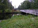
Retrace your route to the bridge. Turn right. Follow Hwy. 343
southward 3 miles to
{3} the Battlefield.
Hawkins' troops charged across the fields to the left of the
historical marker. The 6th New Hampshire's famous volley was fired
from the field on the right.
Continue driving south on NC 343 ten miles to the
{4}
Camden Court House, where Union troops released jailed prisoners
and ransacked several buildings on the way back to their ships at
Chantilly. Continue south to the stoplight and turn right (west)
onto Hwy. 158, following .9 miles to the stop light at Country Club
Road.
Turn left at the stop light onto Country Club Road. Proceed .7 miles
- Turn right onto Chantilly Road.
{5}
Chantilly. Continue .6 miles to the waterfront, where Union
forces landed on April 19, 1862.
Return back to the intersection (.6 miles) to Country Club Road.
Cross over the intersection and follow Seymour's Lane (.9 miles) to
Hwy. 343. Turn left at the stop sign, travel .7 miles - Turn right
onto {6}
Gumberry Road. Hawkins' 4th Brigade made their wrong turn in the
dark here.
At the end of Gumberry Road turn right on 158 to Belcross. (1.2
miles) Turn left onto Lamb's Rd. at the flashing light.
{7}
Alonzo Bell's House, where the 4th Brigade ate breakfast, stood
near Harris Underground Utilities.
Follow Lamb's Road to
{8} Lamb's Corner, (6
miles) where Reno's 2nd Brigade drew up in battle formation, facing
Hawkins' 4th Brigade approaching from the east.
Turn right on NC 343. Follow NC 343 past the battlefield to US 17.
Continue north on US 17 and return to the
{1}
Dismal Swamp Welcome Center. |
|
Top of Page
|
|
Image Map: Click Tour Stops to View Related Photos |
 |
Battle Description-Driving Directions-Map
Courtesy of the
Battle of South Mills Driving Tour Brochure
Top of Page
Battle of South Mills, NC
Page1 2
3
Next
Enlarged Views: Select Back Button to
Return |
|