|
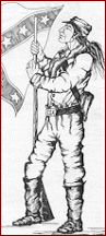
On February 1, 1864, approximately 1,500 Union
soldiers under Colonel William A. Phillips set out from Fort Gibson,
IT on an expedition to cut a swath through Confederate Indian
Territory from the Arkansas River south to the Red River. Col.
PhillipsÆ mission was to bring Indian Territory under Union control
and offer amnesty to Creek, Seminole, and Chickasaw Indians provided
in President Lincoln's Emancipation Proclamation
 of
the previous December. Colonel Phillips also wanted to sever
Confederate treaties with the tribes and gain new recruits. Phillips
chose the old ōDragoon Trailö route west of the overused Texas Road
for two reasons: (1) the Dragoon trail headed directly toward all
three Indian nations he wished to control, and (2) he expected to
find more forage (corn) along it to feed his little army, which he
did. Three companies of the 14th Kansas cavalry led by Major Charles
Willetts served as the spearhead of PhillipsÆ Expedition. During the
month long campaign, the Federals subsisted off the land, raided
Indian settlements, and fought one savage battleŚThe Battle of
Middle Boggy. of
the previous December. Colonel Phillips also wanted to sever
Confederate treaties with the tribes and gain new recruits. Phillips
chose the old ōDragoon Trailö route west of the overused Texas Road
for two reasons: (1) the Dragoon trail headed directly toward all
three Indian nations he wished to control, and (2) he expected to
find more forage (corn) along it to feed his little army, which he
did. Three companies of the 14th Kansas cavalry led by Major Charles
Willetts served as the spearhead of PhillipsÆ Expedition. During the
month long campaign, the Federals subsisted off the land, raided
Indian settlements, and fought one savage battleŚThe Battle of
Middle Boggy.
Before departing Fort Gibson for Fort Washita and perhaps North
Texas, Colonel Phillips told his men, "Soldiers! I take you with me
to clean out the Indian Nation south of the (Arkansas) river and
drive away and destroy rebels. Let me say a few words to you that
you are not to forget ... Those who are still in arms are rebels,
who ought to die. Do not kill a prisoner after he has surrendered.
But I do not ask you to take prisoners. I ask you to make your
footsteps severe and terrible. Muskogees! (Creeks) the time has now
come when you are to remember the authors of all your sufferings;
those who started a needless and wicked war ... Stand by me
faithfully and we will soon have peace ..."
On February 11 the Union troops, marching down the 1855 Dragoon
Trail of US 2nd Cavalry fame, pushed through the Creek Nation and
reached the north bend of the South Canadian River at old Fort
Holmes near Edwards Post at the mouth of Little River (five miles
southeast of Holdenville, OK and 105 miles from Fort Gibson). Here
Colonel Phillips camped for the night, hoping for the arrival from
Ft. Smith of the remaining nine companies of the 14th Kansas Cavalry
commanded by Colonel Thomas Moonlight. They would never arrive.
With the return of his own cavalry raiders into the Seminole Nation,
on 2-12 Colonel Phillips sent his 1st Indian Home Guard (IHG) under
Col. Stephen H. Wattles south across the South Canadian to begin his
advance down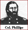 the Dragoon Trail southwest (S20W) toward Shawnee Town and Middle
Boggy River, about 19 miles away. WattlesÆ advance was supported by
two howitzers of Captain Solomon KaufmanÆs artillery. The 3rd Indian
Home Guard (Phillips old command) followed PhillipsÆ wagon train as
a rear guard.
the Dragoon Trail southwest (S20W) toward Shawnee Town and Middle
Boggy River, about 19 miles away. WattlesÆ advance was supported by
two howitzers of Captain Solomon KaufmanÆs artillery. The 3rd Indian
Home Guard (Phillips old command) followed PhillipsÆ wagon train as
a rear guard.
Five miles south of the river (near Atwood, OK), the Dragoon Trail
joined the Marcy Trail (California Trail) for about 10 miles while
climbing past Shawnee Town (north of Allen) then down to a road
junction (near Allen). Nearby were located Motes Springs
(campgrounds) and the northern headwaters (Little Sandy Creek) of
Middle Boggy. An eastern short-cut of the Marcy Trail (the newer Ft.
Smith-Ft. Arbuckle supply road from Gerty/Stuart) joined the Dragoon
Trail here. The old and little used (in 1864) Marcy Trail proceeded
southwest along the Shawnee Hills toward Ada. OK 1 highway follows
the Marcy Trail from Atwood thru Allen toward Delaware Mount (near
Ada). This legacy (1849-59) western trail then passed Camp Arbuckle
of 1850-51 (2 miles NW of Byars) on its way to Santa Fe, NM and
California.
Proceeding S20W four miles past Allen junction along the eastern
side of Little Sandy Creek, the Dragoon Trail crossed Middle Boggy
(whose western headwaters are near Ada) just below both the mouth of
Little Sandy and the formal Chickasaw/Choctaw Boundary of 1855. From
the crossing, the Dragoon Trail headed southwest about 17 miles to
the Clear Boggy ford just below the mouth of Bois d`Arc Creek near
old Stonewall and Colbert Institute. The Ft. Arbuckle military road
continued southwest past CochranÆs Store (and Trading Post) to Fort
Arbuckle (near Davis). Near CochransÆ Store, the Dragoon Trail
turned south between Clear Boggy and Blue River to Fort Washita.
Dragoon Trail was sometimes called the ōTexas Cattle Trailö and it
closely followed the Blue River along its eastern side in Johnston
County until it crossed the Blue near Milburn.
Expecting a Federal invasion based on spy reports from Ft. Gibson,
Confederate Brig. Gen. Douglas H. Cooper had established an outpost
on the Dragoon Trail near Middle Boggy. Confederate forces at the
outpost, under
 the
command of Captain Jonathan Nail, may have numbered as many as 90 poorly
armed men who had no artillery. They were composed of Captain Nail's
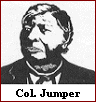
Company "A" of the First Choctaw and Chickasaw Cavalry, a detachment
of the 20th Texas Cavalry, and a part of Lieutenant Colonel John
Jumper's Seminole Battalion of Mounted Rifles. The rest of JumperÆs
battalion was camped southwest of the outpost along the Dragoon
Trail to Clear Boggy. (A plausible campsite was at Red Springs, an
old Indian settlement near Sincere Creek crossing.) the
command of Captain Jonathan Nail, may have numbered as many as 90 poorly
armed men who had no artillery. They were composed of Captain Nail's
Company "A" of the First Choctaw and Chickasaw Cavalry, a detachment
of the 20th Texas Cavalry, and a part of Lieutenant Colonel John
Jumper's Seminole Battalion of Mounted Rifles. The rest of JumperÆs
battalion was camped southwest of the outpost along the Dragoon
Trail to Clear Boggy. (A plausible campsite was at Red Springs, an
old Indian settlement near Sincere Creek crossing.)
Early on the morning of 2-13, Col. Phillips sent most of his
refreshed cavalry of about 350 well-armed men under Major Willetts
for a surprise attack on the remote outpost a few miles ahead of the
line of march, passing WattleÆs 1st IHG infantry column bivouacked
north of Allen. This mobile force consisted mainly of the three
companies of the 14th Kansas Cavalry.
Capt. NailÆs Confederates were completely surprised by the cavalry
attack. The Confederates fought desperately for about thirty minutes
before scattering toward Colonel Jumper and the rest of his Seminole
Battalion. During the night the Confederates fled south, some toward
Boggy Depot. By the next day, Brig. Gen. Cooper, located about 45
miles away from the outpost at Boggy Depot, had been informed by
Capt. Nail of the shocking defeat and Union advance toward old
Stonewall.
Major Willetts, following the directives he had been given, had
taken no prisoners. The bodies of the wounded that Capt. Nail had
left unburied on the battlefield were discovered later by the
Confederates to have had their throats cut. Major Willetts reported
no Union casualties in the Battle of Middle Boggy. The Federals
initially reported 47 Confederate killed, later increased to 49.
Brig. Gen. Cooper reported 11 Confederates died, including 4 from
NailÆs command. Col. Phillips camped on the northeast side of Middle
Boggy for the night, naming the site Camp Kansas. PhillipsÆ dispatch
to Ft. Smith the next morning showed he believed he was still in the
Choctaw Nation. The Dragoon Trail west of Middle Boggy crossing to
near Ft. Washita had been the defacto eastern boundary between the
Chickasaws and Choctaws from 1837-1855, (when a new treaty was
approved), and this segment of the Trail became the practical
national boundary from 1856 until 1872 when a federally approved
initial land survey of the Chickasaw Nation was completed.
By the morning of 2-14, the morning after the battle, Col. Phillips
knew that the remaining 9 companies of the 14th Kansas cavalry were
not coming. Invading North Texas now was not feasible; however,
communicating President LincolnÆs new amnesty proclamation to the
Confederate Indians was. Col. Phillips divided his command, sending
his mounted forces under Maj. Willetts south 21 miles (probably
measured from PhillipsÆ HQ) pursuing the fleeing Confederates, and
seeking Chickasaw Gov. Winchester Colbert, who sometimes resided
near Colbert Institute and the (seldom used) Pontotoc District Court
House (near old Stonewall/Frisco) on Clear Boggy. Col. Phillips
followed WillettsÆ van and camped that evening at Camp Kagi (John
Henry Kagi
was a John Brown martyr at Harpers Ferry) on Clear Boggy (1.5 miles
southwest of old Stonewall near CochranÆs Store). Phillips ordered
Col. Wattles to take the remainder of the straggling command (mostly
Indian infantry since only the 1st IHG had reached Middle Boggy
battlefield the afternoon of the battle) and return to old Ft.
Holmes, which Col. Wattles did late in the evening of 2-14.
Circumstantial evidence suggests that the battlefield was located
along the Dragoon Trail (or Texas Cattle Trail) near its crossing of
Middle Boggy River between the Ft. Smith-Ft. Arbuckle junction just
south of Allen, OK and the small community of Steedman about 2 miles
southwest of the Middle Boggy River crossing. The proposed site is
located in extreme northeastern Pontotoc County, Oklahoma.
Col. Phillips headquarters for the night of 2-13 (Camp Kansas) were
most likely located just south of Allen and the trail junction (on
high prairie land near Motes Springs) and not across Middle Boggy
River, otherwise Phillips would have been in the Chickasaw Nation--
a well-known fact in 1864 which Col. Phillips surely knew. At this
site for Camp Kansas, Phillips would have a nearby cross road
junction to Ft. Smith (which he may have used for his dispatch of 2-14 to
Brig. Gen. Thayer, commanding at Ft. Smith), a well-known clear
headwaters springs, elevated open space for good defensive purposes,
and most of his little army. While the 1st IHG arrived at the
battlefield that afternoon, neither the 3rd IHG nor the wagon train
did. Thus, the battlefield itself was most likely located a few
miles ahead of Camp Kansas, very near the Middle Boggy crossing. The
remaining question is ōOn which side of Middle Boggy, the east or
west?ö
Several bits of evidence suggest the northeast side (nearer to
Allen). Col. Phillips initially reports on 2-14 that the Indian
enemy were Choctaw (an east-sider) and not Chickasaw (a west-sider).
Gen. Cooper notes the enemy is 45 miles from Boggy Depot. The east
side (nearer to Allen junction and HQ) fits this distance better.
The distance Col. Phillips later states Camp Kansas is from Camp
Kagi is 21 miles, which fits nicely with his HQ being near Allen,
and not at the river crossing 4 miles ahead with the bloody
battlefield likely being on the west side. The Confederates were
surprised and slaughtered. Confederates defending an east side (or
suicide) outpost directly exposed to an enemy cavalry charge with
rebel backs to the river, logically fits the results better.
Willetts had good flanking attack paths from Allen junction with two
pincer routes well hidden and linked to an east-side outpost. A path
for a western flank attack along the old Marcy Trail (say OK 1) from
Allen lay just to the west along Little Sandy Creek, and an eastern
flank attack could easily follow the path of OK 48 highway from
Allen as it would lie just east of the Dragoon Trail behind some
hills. Both flanking routes would arrive just behind an east-side
outpost without fording Middle Boggy. The Confederates would have
been sitting ducks to such a large well-hidden mobile three-column
attacking force. Capt. KaufmanÆs two howitzers could have signaled
the start of the attack on the outpost from several elevated
positions near the Dragoon Trail east of the river crossing. A
Confederate casualty rate exceeding 50% suggests this is what
happened, given the reported zero Federal casualties.
A re-enactment of the Battle of Middle Boggy is hosted every 3rd
year by the Atoka County Historical Society. The next re-enactment
will be held in the year 2015.
Dr. Carroll Messer, Ph.D,
TAMU, College Station, TX
 Return to Phillips' Expedition of 1864 into Pontotoc County,
Oklahoma Return to Phillips' Expedition of 1864 into Pontotoc County,
Oklahoma
|