|
(Sept. 19, 2010) Enlarge
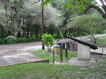
Yellow Bluff Fort
Yellow Bluff Fort is located on the northern side of the Saint John's
River and is a Florida State Park. The site is next to a semi-trailer
facility and is inside a manufactured home park. There is no visitor
center, no staff, nor facilities, but there are cannons (see photo) and a
monument to Confederate troops. The Fort at Yellow Bluff is really close
to being a "T"-shaped earthwork which has seen plenty of bike action and
metal detectors, hence the sign.
Yellow Bluff Fort is located in north Jacksonville, Florida on New Berlin
Road. From 9A,exit to Heckscher Drive east. Take New Berlin road south
from Heckscher Drive. Yellow Bluff Fort is approximately 2 miles on the
right. There is a marker and picnic tables. The site is open daily.
Today the area not too far from the site is a cargo port and a cruise ship
terminal. The Napoleon Bonaparte Broward Bridge is nearby. Heckscher Drive
is the first exit before crossing the bridge from the north side and the
first exit after the bridge if coming from the south side of the St.
John's River. This section of Jacksonville, Florida is often referred to
as "Dames Point"
Enlarged Views: Hit Back Button to return |
|
|
(Sept. 19, 2010) Enlarge
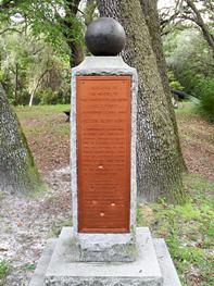
Confederate Monument at Yellow Bluff
The text of the marker is:
Dedicated to the memory of the Confederate soldiers who defended
Jacksonville, 1861-1865.
Yellow Bluff Fort
A Confederate earthworks designed and located by General Robert E. Lee
as one of a series of forts for the defense of the Saint Johns River.
This fort was occupied by both Confederate and Union forces during the
course of the war and is today in its original state.
Erected by the United Daughters of the Confederacy
Martha Reid Chapter
Jacksonville Chapter
Annie Perdue Sebring Chapter
Alexander H. Stephens Chapter
Mary Holland McCleary Chapter
Robert E. Lee Chapter
Site Donated by the North Shore Corporation 1950 |
|
|
(Sept. 19, 2010) Enlarge
History of the Entrenchment at Yellow Bluff from the NPS Brochure
"Located on the north and opposite side of the St. Johns River from St.
Johns Bluff, the site known as Yellow Bluff was 5 miles further upriver,
closer to Jacksonville, and also important in protecting access to that
city.
Yellow Bluff Fort was constructed in 1862 by the Confederate army to
"relieve the valley of the Saint John's from the marauding
incursions of the enemy (Union army)." There was never an actual fort on
Yellow Bluff, but a fortified encampment with T-shaped earthworks and
equipped with large guns for protection. Federal troops seized it from the
Confederates in 1862 and held it for the remainder of the war.
After a Confederate victory in the Battle of Olustee west of Jacksonville
in February 1864, and in anticipation of a possible Confederate attack on
Jacksonville, Federal forces refortified Yellow Bluff, strengthening the
existing earthworks and building new ones amid "the almost impenetrable
jungle" that covered the Dames Point peninsula. A signal station was built
and all ships operating on the St. Johns River were ordered to anchor only
at Yellow Bluff. By the end of March, 1864, Yellow Bluff was home to 346
enlisted men and 10 officers, mostly from the 55 Massachusetts Regiment
(Colored). Federal troops maintained control of Jacksonville for the
remainder of the war and continued to be stationed at Yellow Bluff until
hostilities ceased." |
|
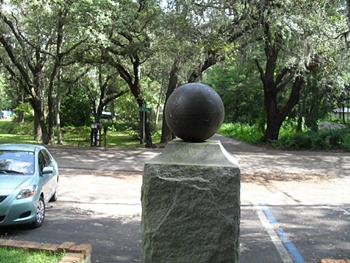
(Sept. 19, 2010) Enlarge
View of Yellow Bluff Monument from Reverse
The parking area and streets on the community can be seen from the back of
the CSA monument. This fort is really an undeveloped site in a neighborhood
and at first glance appears to be just a picnic area with two benches. At
the time, there were no trees and about 350 troops in this area which is now
off- the -beaten -path. From the reverse of the monument you can also see
the small parking area. |
|
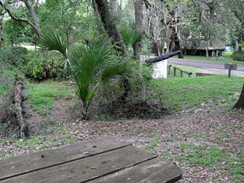
(Sept. 19, 2010) Enlarge
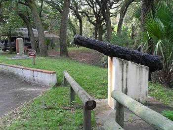
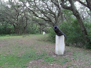
Cannons at Yellow Bluff Fort
The cannons are mounted on concrete bases and interspersed around the
picnic area. The overgrown entrenchments can be seen behind the cannon in
this photo. While the entrenchments were described as a "T"-shape by the
National Park Service, we noticed the entrenchments did not seem to be a
standard "T" but this may be due to the ravages of time. The cannons
appeared to be from an earlier era, but it was impossible to determine
much about the guns as a result of their corroded condition. Through the
trees it was possible to see the river and imagine this as a strategic
location. |
|
(Sept. 19, 2010) Enlarge
Yellow Bluff
The Yellow Bluff Fort Florida State Park is small park in a neighborhood
so when in use during the war it must have been larger than the current
small protected area hence this view is presented for the imagination.
During the war, Dames Point/Yellow Bluff was and still is located in a
Humid Sub-Tropical Climate. Visitors are strongly encouraged to bring
mosquito repellant and sunscreen. |
|
(Sept. 19, 2010) Enlarge
View of Picnic Area at Yellow Bluff
When we first arrived in the neighborhood on Sunday Sept 19, 2010 we
thought we were in a some-what neglected park with a cannon and two picnic
benches. We never would have guessed we were in a site of a fort as it
looked just like a roadside park someone might find in many parts of
America with a cannon, monument, and picnic tables, but after closer
inspection the site revealed itself as the remains of Yellow Bluff Fort.
Please notice the earthworks to the left side of the photo. Imagine what
stories the trench could tell. |
|
|
