Matagorda County, Texas Civil War Sites

Photos/text this page courtesy of William Bozic, Houston, TX
For any use of these photos contact
Webmaster
  Links:
1. Confederate Defenses at the Mouth of Caney Creek: hmdb.org
2. Handbook of Texas Online - CANEY CREEK
3. Col. Julius G. Kellersberger: Confederate defenses engineer
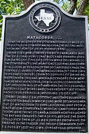
     

(July 21,  2008) Enlarge Texas Historical Commission marker for Confederate Defenses at the Mouth of Caney Creek
 
This marker is located just yards from the end of FM 457 not too far from where the bridge starts. The marker is on the East side of FM 457. Time and hurricanes/storms have taken their toll on the earthworks.
 
As the marker states plenty of Confederate troops were stationed here. The following is a partial list taken from the book CONFEDERATES ON THE CANEY by Bobby McKinney (self-published) page 127.
 
2nd Texas Infantry Regiment
Debray's 26th Texas Cavalry Regiment
Gould's 23rd Texas Cavalry Regiment
Terrell's 37th Texas Cavalry Regiment
1st Texas Mounted Rifles (AKA Buchel's 1st Texas Cavalry Regiment)
McMahan's Texas Battery
Gibson's Texas Battery
Jones' Texas Battery
Confederate States Engineers
 
Not listed in the aforementioned text, were Ruben Brown's 35th Texas Cavalry Regt and James B. Likens' 35th Texas Cavalry Regt. (Yes, there were TWO Confederate Cavalry Regiments from Texas with the same numeral and both were in operation in the same location during about the same time)


(July 21,  2008) 
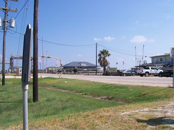
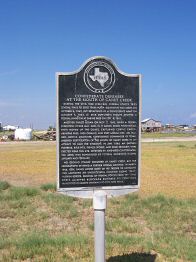
Enlarge Confederate Defenses on the Caney marker, looking towards the Caney
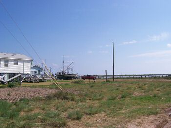
To the left hand side the Texas Historical Commission marker for the Confederate Defenses at the Mouth of the Caney can be seen. To the center and right are the intracoastal waterway and Caney Creek. At this location the name "Creek" is a bit odd, because the Caney looks like a river. There are some fishing supply stores and restaurants along the banks of the Caney

(July 21, 2008) Enlarge The Caney Creek (River) can be seen. This photo was taken from the Eastern side of the Caney. The Caney was important to blockade runners
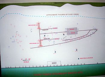
This photo was taken July 21, 2008. Hurricane Dolley hit to the South only two days later. This location was pelted with heavy rains and strong winds from the arms of Hurricane Dolley


(August 2009) Enlarge Matagorda County Museum. Caney Creek Shipwreck Exhibit

Matagorda County Texas was, and still is, a major agricultural area. Rice, Cattle, Cotton, etc were raised and grown which aided the Confederacy, so Matagorda County was subject to raids from Federal forces. The Colorado River, Caney Creek, and Brazos River were popular locales for blockade runners which caused the Union navy to heavily patrol offshore

William Watson of the blockade runner "Rob Roy" wrote of his exploits in The Civil War Adventures of a Blockade Runner (London) 1892. The Rob Roy escaped the blockade from Velasco, Texas which is along the Brazos River, not too far from Caney Creek but in a different county. Not all blockade runners were as lucky


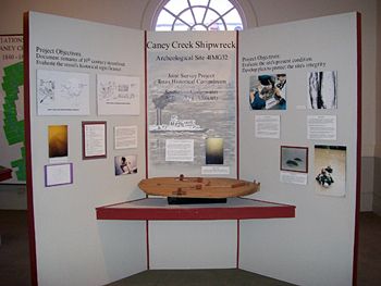
(August 2009) Enlarge Caney Creek Shipwreck Exhibit


(August 2009) Enlarge Grape Shot fired at CSA Fort Caney during the War Between the States

The original fort is now washed away by shore erosion. The best source for information about the CSA defensive works at Caney Creek is: Sergeant Beach Project: A History of Confederate Defenses at the Mouth of Caney Creek, Matagorda County, Texas by Martha Doty Freeman and Elton R. Prewitt (Prewitt and Associates: Austin, Texas) April 1994. Confederates on the Caney by Bobby McKinney (self-published) is also an outstanding source and highly sought-after.

Among the many Texas Confederate units serving in the Caney Creek area, were Buchel's 1st Texas Mounted Riflemen, Col. James B. Likens' 35th Texas Cavalry Regiment, and Col Ruben Brown's 35th Texas Cavalry Regiment.

Lt. Sam Houston, Jr. (Son of the famous Sam Houston) served here with McMahan's Texas Artillery and drew a sketch of a fortification. The sketch is held at the Sam Houston Memorial Museum in Huntsville, Texas


(July 21,  2008) Enlarge CSA Monument, Matagorda County Courthouse, Bay City, Texas


(August 2009) Enlarge
 
Matagorda, C.S.A.
Bay City, Texas
Year Marker Erected: 1964
Location: Courthouse Square, south end; Bay City

Marker Text:
Near the mouth of the Colorado River, 20 miles to the south, is the town of Matagorda, the second most important Port of entry in early Texas. In the Civil War, center for rich farmlands and one of 8 Texas ports that blockade runners used for taking out tons of cotton while delivering to the Confederacy guns, munitions, clothing and other vital goods. By reason of the declared blockade, the Federals claims to hold Matagorda, yet their own ships had to refuel (even to supplies of drinking water) in New Orleans. When a blockader's crew went ashore near Matagorda, on November 20, 1862, Confederates captured every man. By hit-and-run tactics, Federals destroyed salt works and other property, but found Matagorda Peninsula impossible to occupy. On December 30, 1863, C.S.A. cottonclads (ships bulwarked with cotton bales in which guns were set) moved men out of Matagorda to expel a Federal unit from a beach below Confederate works at Caney Creek. When CSA troops were trying to land, a sudden norther lashed the bay and swamped their skiffs. Before the ships could pick them up, 22 men died by drowning or freezing. In the tragedy, the troop commander, Capt. E.S. Rugeley lost his own 17-year-old brother.

NOTE:
1) The men who died due to the sudden Norther were part of Col. Brown's 35th Texas Cavalry Regiment, not to be confused with Col. Likens' 35th Texas Cavalry Regiment which operated in the same region during this time.

2) "Norther" refers to strong storms coming from the North during the winter that send freezing temperatures and chilly winds in abrupt changes to the weather along the Gulf Coast. Even in Mexico these storms are referred in Spanish as "Un Norte" = A Norther.

Sites by State Home         Site Index