Battle of Dranesville, Virginia
Courtesy
of Robert B. Yates Please contact Webmaster for any use of following photos |
See Links for Additional Information |
June 1, 2002 These pictures and the accompanying text are copyright 2002 by Robert B. Yates. Permission is granted to Mr. Bruce Schulze and/or www.Civilwaralbum.com for the non-commercial use of the pictures and text. Dranesville, Virginia is located in far western Fairfax County at the junction of Virginia Routes 7 and 228, about a mile from the battleground. The only surviving structure from 1861 is the historic Dranesville Tavern. The actual fighting took place at what is now the junction of Virginia Route 7 (Leesburg Pike) and Virginia 193 (Georgetown Pike). As a practical matter, much of the battlefield, including its topography has changed. For example, the grassy area in picture 6 was a hill in 1861. Photographs in this article were taken on December 15, 2001, the actual battle took place on December 20, 1861. |
![]() |
![]() |
||
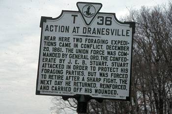
(12-01) Virginia Historical marker located on Virginia 7 east of Dranesville |
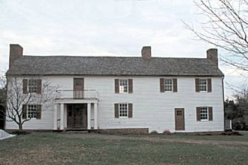
(12-01) Historic Dranesville Tavern. Built 1820, it was moved to its current location as part of a road widening project along Virginia 228 (Dranesville Road). The Tavern is operated by the Fairfax County Park Authority and can be rented for weddings, parties, etc. |
||
![]() |
![]() |
||
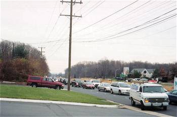
(12-01) Looking east down Leesburg Pike in the direction of Difficult Run. Reynolds brigade of Pennsylvanians were in support at Difficult Run, four miles to the east. White building in right background is a Fairfax County firehouse built at the junctions of Leesburg Pike and Ox Road (Virginia 602). In 1862 Lee moved to this area from Chantilly |
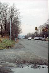
(12-01) Looking west down Leesburg Pike toward Dranesville, and the approximate center of the Union line in the direction of Stuarts advance |
Dranesville Page1 Page2
Return to Misc. Sites Home Site Index